Archive for the ‘Outdoor Recreation’ Category

Wezil Walraven – Birding Tour Guide

February 20th, 2013 by Mike Hug

Since our bnb is on the San Pedro River at the northern end of the San Pedro National Riparian Conservaiton Area, we have many birding guests at Down By The River B and B. They will relate to us what they found and the locations that they have been at during their trip. A recent guest couple told us about their experience with a “Wonderful Birding  Tour Guide” that they had met when they first came to Cochise County to stay on a birding vacation. They told us of a couple of tours that he was their guide and escort. They raved about how he was able to take them to just the right areas and finding the birds that they had hoped to see on their trip to Cochise County, Arizona. With their rave review of the tour with their guide, we asked for his name and contact information. Since we are in a centralized location for Cochise County, we felt that learning about the guide might be a great benefit to our birder guests. We made an effort to contact Wezil and set up a time to meet and talk with him.

Angie and I finally were able to meet with Wezil Walraven on February 19th when he stopped on his way home to New Mexico after spending time in Southeastern Arizona doing tours. Wezil told us that he is of Dutch decent and his name is pronounced like the animal, weasel although in Dutch it is Vesil. He told us that he had been doing birding for almost 40 years and really enjoys working with his clients. He told us that he was more of a teacher than a guide. He wants to be able to give them some guidelines to use when they are on their own. He also told us that he likes to have fun birding and related some stories about things that he has done.

Vermillion flycatcher picture

Vermillion Flycatchers are found in the San Pedro River area and on the property of Down By The River B and B in St.. David.

Wezil is a senior tour guide for High Lonesome Bird Tours. He told us that he has gone all over doing tours but tends to stay in Southeastern Arizona and his home state of New Mexico. When he isn’t doing the High Lonesome tours he does his own tours under the name of Wezil Walraven Bird Tours. When he does a High Lonesome tour in this part of Arizona, he also can set up a reservation for private tours before and after High Lonesome tour before he returns back home to New Mexico. He told us that he has acquired a good knowledge of birds, their songs and behavior as well as knowledge of their habitat. He demonstrated some of the songs and gave us some insight on what we could find out the back door of our BnB on the San Pedro River.

To that end he talked about our area here at the Northern End of the San Pedro River National Riparian Conservation Area. He was telling us that there are Gray Hawks and Western Screech Owls along the river in this area. He also confirmed that we had probably seen Golden Eagles last year and the Mississippi Kite in early February. He said that the Mississippi Kite used to be in the Winkleman area and had migrated down into this area maybe 10 years ago. He said that this is one of the unique locations for finding this bird and the Gray Hawks. As we talked, he told us that March through May are good birding months in this part of the state. But he went on to state that June is very good too. That is because the birds are nesting and they stay close and are therefore easier to spot.

Wezil can be contacted through his website, email wezil@wezilwalravenbirdtours.com or phone him at 828-575-3107 to set up a tour reservation. Angie and I believe that you will be pleased with your experience with Wezil.

White Water Draw Part II

February 10th, 2013 by Mike Hug

This is Part 2 of my blog on White Water Draw. If you haven’t read about Part 1, click here.

Sand Hill Cranes in Field

The Sand Hill Cranes feed in the fields north of White Water Draw during the day.

When we arrived at White Water Draw, we were alone and I wondered why.  More than likely it was because it was cold outside and the smarter people decided to stay at home for a while. Well after we were at the barn another couple drove up so I figured ok it isn’t a holiday for the cranes after all. But I am digressing for those that read Part 1 so I will fast forward to about 10:45. Angie and I saw the cranes when we were near the Willcox Playa on our way to Cochise Stronghold for our hike. There is a corn field  that is located on the  side of the road that we were traveling on to the Stronghold Campgrounds.

Angie and I were on the levee and a few straggler cranes had flown over to land among the group that was about 100 yards/meters away from our location. When a new arrival flew in there was a chorus of honks until the new arrival landed then it quieted down. We had been informed that the cranes usually returned from feeding between 10:30 and 11:00. But it seemed that there were no birds in the air except a group of 3 or 4 or the singletons.

3 Sand Hill Cranes Returning

Three Sand Hill Cranes Arrive while others can be seen in flight returning to White Water Draw.

These birds were usually coming from the south and since I didn’t believe that there were any fields south of us I was wondering why they would come from that direction. Still don’t know unless they came from the southeast.

11:00 AM and Angie and I are on the platform at the water’s edge.  I am saving my battery then I see a small group of 7 fly in from the east. Battery on focus but the shot is not what I want so battery off. We are talking with other birders that have arrived and they were out of town from Illinois.  More people arrive on the platform including a couple of people that we had passed on the drive in. They were on bicycles when we passed them. We didn’t ask where they came from but it had to be from Tombstone, Sierra Vista area or Bisbee the closest being 30 miles. I don’t mind biking and I have done my share when I was younger and dumber on roads like Davis Road. Wouldn’t do it today it might leave a permanent dent in unseen places and not necessarily from my error. Now a tour bus arrives and the people are given their box lunches. Obviously someone knows about timing this better than I do. I think I should contact them to find out what the real facts are next time I plan a trip.

Sand Hill Cranes Returning Picture

When the Sand Hill Cranes arrive they come in waves.

It is 11:20 and still nothing. Now I am starting to wonder if this will be a bust. I figured we could go to 11:30, shoot these wonderful “National Geographic Shots” and then we would be traveling back to have lunch in a perfect world. But the birds are saying “I laugh at you!” We see all sorts of ducks, teals, plover, and the snipe less than 20 feet away. Great shots but do I waste the battery ….NO! I will kick myself later after I get home and charge the batteries. 11:25 arrives with more people on the platform but at least we are in front. I tell Angie we need to leave by 12:15 if there is no action.  We hadn’t brought any food and I figured by 12 we would be close to Bisbee and a quick lunch in the PERFECT WORLD.

It is 11:45 someone says they see some birds. I look north and see some irregular black lines in the air. But wait there are cranes down low coming into the lake area. The mountains behind them sort of hide them from view because they are similar in color.  As we looked we saw more and more. Now it is time to turn on the camera battery. The cranes on the ground seem to be

Sand Hill Cranes Returning Picture

After 20 minutes the cranes are still arriving at The Draw.

doing the chorus of greeting to the newcomers.  As wave after wave come in the birds land it different areas with some being closer about 50 yards away. This is really grand. The birds are doing a dance in the air as they find a place to land. At one time the birds converge at the point in front of us and flair out some to land and some to go to another location.  Focus click, focus click.  I am thinking if only I hadn’t made the mistake with the batteries and if I had my regular lens.  Que Sera Sera, Estupido!

12:00 brings more flights and I look to the horizon and see black strings of birds still on their way. Already thousands have landed and more are coming. The noise is pervasive and I remember that Barb had said that it almost sounded like something you would hear in prehistoric times. The birds keep coming and now that I have some shots that I feel are good I don’t want to waste shoot something that may not be as good as what was coming. This is a tragedy because if the batteries were good I would shoot until the memory card was full – maybe a thousand shots. That makes digital cameras so nice because you don’t have to process the film if it isn’t any good.

12:15 comes around and the black lines have lessened.  Now it seems like only stragglers are coming, so I ask Angie if we can go. We head back and to the car and on the way I take a shot back at the people that are still

White Water Draw View Area Picture

Many birders come to see the action at White Water Draw. There is a large viewing area for people to watch.

there watching. The sun is starting to come out and I get a pretty good shot across the field with the automatic focus turned on. Amazing I still have batteries even though it tells me every once in a while that it is depleted.  We get in the car and head back home at about 12:40. As we are headed west on Davis road we watch another flight of Sand Hill Cranes with maybe 40 birds in it fly over us to the Draw. I see another group further on north coming. I would like to think that at that time the trip home would be uneventful but NOT! Davis Road was undergoing maintenance during the day and part was closed down and controlled by the highway department. You had to wait your turn and be piloted through. Unfortunately a van and a truck had an accident while following the pilot car but we weren’t involved.

There are at times an estimated 15 to 20 thousand cranes are at White Water Draw. My guess at the total population of birds in the area is close to 30 thousand during this time of the year. I have been here during the summer and late spring and found the area still to have birds but the water is pretty much gone. There are still some birds around but at a small fraction of what you see in December through March. Many of our guests at our San Pedro River B and B have no idea about White Water Draw. They have heard about the Willcox Playa from their birding friends but after they go to White Water Draw they fall in love with the place.

So if you are an amateur or an avid birder, consider visiting Cochise County in Southeastern Arizona and see what there is for you to see. When you come also realize that The San Pedro River B&B, Down By The River is central to all your birding activities and you will find that it is the Lodging Hub of Cochise County. Oh and as a reminder, make sure your camera equipment and batteries are in good repair.

White Water Draw Wildlife Area Part 1

February 4th, 2013 by Mike Hug


View Larger Map

Sign Picture

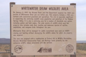
The sign at the entry to White Water Draw tells you about the property

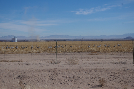
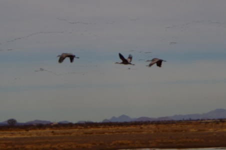
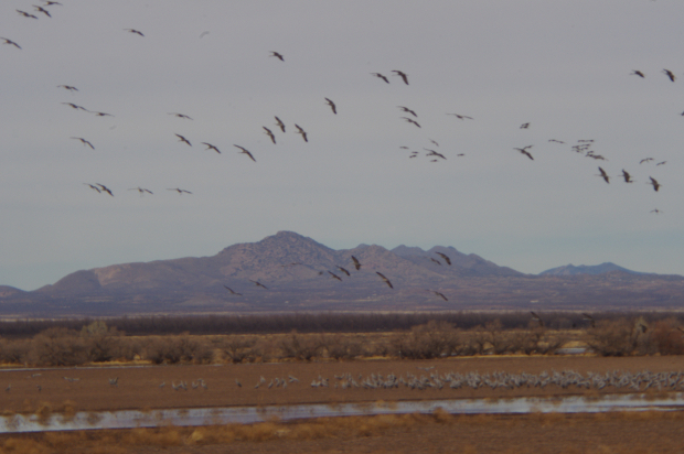
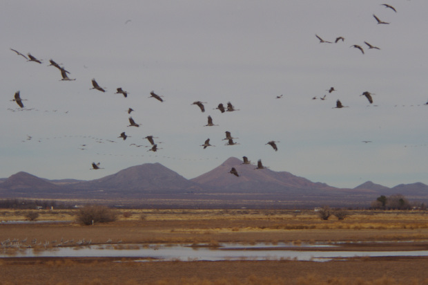
White Water Draw is a birder’s paradise during the late fall, winter and early spring. This place is located in Cochise County about an hour south and east of Down By The River B and B. The 1400 acre site has been owned by Arizona Game and Fish Department since 1997 when it was purchased from the Hyannis Cattle Company. About 700 acres is wetland and is known as a wintering area for Sand Hill Cranes and Snow Geese. After talking with guests Barb and I had gone to the area during the early spring after we had first opened the B & B 8 years ago.  Angie had never been there, so at the beginning of February we had a chance to sneak away for a couple of hours before our next guests were to arrive at the B & B for check in. We really were looking forward to this and I wanted to have the chance to get some good pictures of the action there.

The Barn Picture

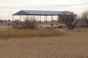
The Barn At White Water Draw Is Home To Owls

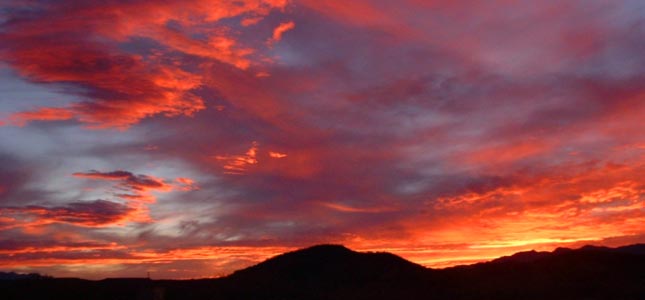
The cards seemed to be stacked against me as I gathered things together prior to making the trip. We didn’t have a great sunny day like we hoped to have, and the temperature that morning was cooler as we headed off. My one zoom lens that I always use for occasions like this had recently become disabled and wouldn’t focus so I had to improvise. I had some magnifiers that I could put onto the shorter camera lens and I hoped that doing this would work. I anticipated that I would not be as satisfied with the results between the overcast skies and the lack of my reliable zoom lens. But que sera sera as Doris Day once sang. Just gotta deal with the cards you’re dealt. Little did I know that the deck would be stacked against me in other ways I hadn’t thought of.

Great Horned Owls  Picture

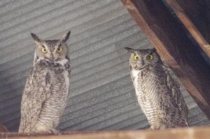
Great Horned Owls Can Be Found In The Barn At White Water Draw.

The drive to White Water Draw is about 50 miles and takes under an hour. We headed to Tombstone and drove through town. After a few miles Davis road was on our left and we took it to just after milepost 21. We turned right on to a dirt road named Coffman Road. The road sign wasn’t there but there is a sign for White Water Draw on the road. After about 2 miles we came to the parking area. It was still overcast and cold; so we bundled up and walked over to the barn that sits on the site. “The Barn” is about 30 foot tall and there usually are Barn Owls and Great Horned Owls roosting in it. One owl was there instead of the customary pair. After taking some pictures and saying “How Do” we walked on over to the viewing area to check out what was going on with the cranes and other denizens of the wetlands.

Snow Geese Picture

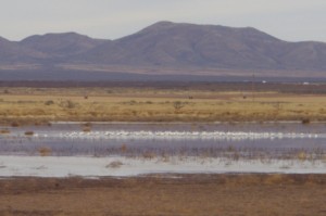
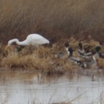
Snow Geese On The Water

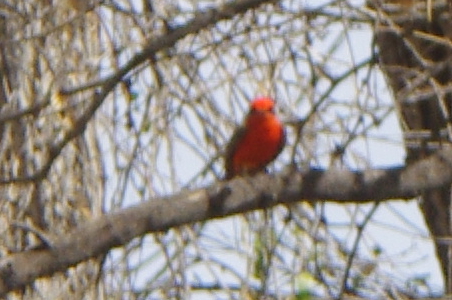
Besides the Sand Hill Cranes and Snow Geese, the area is frequented by many other birds and water fowl. These include Blue-Winged, Green-Winged and Cinnamon Teals, Northern Shovelers, Western and Clark’s Grebes, Mallards, Egrets, Great Blue Heron and many others. The area has many raptors including Northern Harriers and Swainson Hawks. During my previous visits I have spotted Phoebes, different types of Sparrows, Yellow Headed and Redwing Blackbirds, and Vermillion Flycatchers to name a few. It is a good place to see a large concentration of different birds in a small area.

Snow Geese Picture

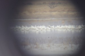
Snow Geese As Seen Through The Magnifiers

As we walked along the levee, we came to one of the viewing platforms constructed at the water’s edge. The platform has free for use, large magnifying glasses that you can use to look at the birds. While at the viewing platform, we saw a Loggerhead Shrike right below us. He was camera shy. Every time I tried to get the shot, he would hear the camera focus quickly duck into the reeds and become almost invisible.  I noticed the Snow Geese and shot some pictures of them grouped on the water. After my shot, I looked through the glasses that were provided to see them better. It was much better than my lens. Then I thought that maybe I could get a shot through the magnifier to get an idea of a comparison of my lens to the viewer. It wasn’t a real sharp picture because I was attempting to focus through another optical instrument. I was semi successful and you can see in comparing the two pictures it does give you an idea of what the magnifiers can do.

Water Foul Picture

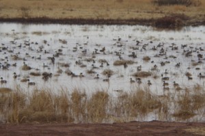
Ducks And Other Water Foul Fill One Of The Ponds

We moved further along the levee and came to the next pond that contained a lot of ducks. We startled them when we walked up to the edge and they saw us. They all took flight and landed a little further away. It would have been a great shot had I known that the ducks were there and been ready for them. But by the time I got the camera on the birds they had gotten settled a little further from shore. There was a multitude of water fowl in the group. It was fun to watch them feed, with tails up in some cases, and others like the Shovelers just put their heads down with the long beaks to root around in the mud.

Egret Picture

Egret Hunting

A little further along, I took some time to check out an Egret that was feeding in the reeds. They exhibit a lot of stealth and wait for the fish to come to them. With a quick move he had a fish but I was so mesmerized by watching what he was doing that I forgot to click the camera and I missed the shot. Not the first time that I have missed pictures because I’m concentrating on what I am viewing. I have to get over that since I can see the action later if I take the picture when I should.

Over the fields to the west we saw some Northern Harriers gliding over the grasslands.  It is a beautiful sight to see these birds gliding through the air. It reminded me of the time last summer when I saw the Harrier that frequented our San Pedro River B & B and how I finally got a series of pictures of the Harrier in flight. But as I watched, the

Green Winged Teal Picture

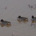
Green Winged Teal Were Out in Plain ViewGreen Winged Teal Were Out in Plain View

Harrier changed paths and flew toward the Snow Geese. In an instant they were up in the air and scattering out of the way. Again, camera down and batteries off so I didn’t get a shot again. You think I would learn this lesson but in the long run it was probably best that I didn’t walk around with the camera always on. While the geese were flying in a circuit, I tried to focus on them as they flew toward us and the automatic focus just wasn’t cooperating. I did get some nice pictures of the gray sky. By the time I had them in focus again they were landing back in the water where they had started.

About this time my battery started telling me that it was getting depleted. Ok, not to worry I always have the spare in the camera case, so I stopped to change to the recharged battery. I put it in and found that it had less of a charge than the one that I had just had in the camera. “DOH!” as Homer Simpson would say.  I forgot to charge it after our walk around Texas Canyon and then our hike to Cochise Stronghold.

Northern Shoveler Picture

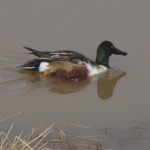
Northern Shoveler Can Be Found Here At White Water Draw.

Now I am in a bind. One battery with one anode in the grave and the other already 6’ under raising daisies! OK, I ask myself, what takes most of the energy to run the camera? Number one is the autofocus. So I put things on manual focus but this really is not the best for what I want to do with the pictures. The manual focus depends more on your eyesight determining what is in focus and what isn’t. Not bad if it is bright out or if you don’t intend to enlarge the picture later. Both conditions will make it more likely for a picture to be blurred. Mas que sera para mi! I don’t have a lot of choices if I want to have pictures.

So what happened? Well, you will have to wait to read about this misadventure in Part 2 of this blog where I will be talking about watching the Sand Hill Cranes come in from feeding in the fields. Consider staying at a Southeastern Arizona B and B with easy access to a lot of Birding in Cochise County. The San Pedro River B&B is located at the northern end of the San Pedro River National Riparian Conservation Area between Benson and Tombstone.

Explore Texas Canyon in Cochise County

January 28th, 2013 by Mike Hug

Texas Canyon Pic

Texas Canyon Back Country Rock Formation

As you drive on Interstate 10 through the Little Dragoon Mountains about 15 miles east of Benson you will find an area that is in stark contrast to the San Pedro River Valley. Texas Canyon is a massive granite formation that has weathered over the eons to create a jumble of rocks that catch the eye. The granite formation can be seen as you drive past on the interstate or when you stop at the rest areas. The rest area gives you some nice views of the rock pillars and boulders but you are fenced in and you can’t really get out to explore the area. If you take exit 318 you will be able to find some spots to wander around and see a little of what is here.

When Barb and I were first coming to southeastern Arizona looking for a location to build Down By The River B and B, we drove through Texas Canyon. We would often think how fantastic the rock structures were in this area. We wished that we could have moved some of this area to Saint David and placed it along the San Pedro River right next to the BnB but alas it was 25 miles away.  The rocks are scattered over a large area and it almost looks like some giant was playing with them and then just left after he was done.

Texas Canyon Picture

Texas Canyon scattered trees offers some shade while you enjoy the views

During the eight years the b and b has been opened, we have traveled past or through Texas Canyon on our way to somewhere else. Usually we have taken the turn off to go to the Amerind Foundation Museum, The Triangle T Ranch for dinner in the saloon, or just to take a shortcut to Arizona 191 on our way to various places in the Sulphur Springs Valley. We never took the time to stop and see what the back country was like.

Recently, Angie and I decided to take a short day trip from Down By The River B and B to Sunsites and head  to the trail head for a hike up to Cochise’s Stronghold in the Dragoon Mountains. Naturally I was going through Texas Canyon as we exited the freeway on Dragoon Mountain Rd. But instead of making the turn and driving on to our destination, I decided to take some time to see what I had been missing. I turned left under the freeway and took 4Y Ranch Road into the back country north of the freeway. The one lane road doesn’t go far, maybe a mile, and you finally reach  the cattle guard and the ranch gate.

Texas Canyon Valley Picture

Texas canyon has some valleys that drop that will beg you to explore them

We backtracked a little and found a place to get off the road. With a nice morning sun, we decided to walk around and see what the area had to offer. It turned out that long with the enticing rock formations, the area has yucca, ocotillo, cactus of various sorts and scattered trees that dot the terrain. We also saw signs of coyote, deer and the occasional bird that fled our advance. On previous travels though the area I have various seen birds fly across the road and I have spotted hawks that are watching for prey. But since this is winter, I didn’t expect to see a lot of activity.

As we walked around the area we notice the rocks were crossed by thinner lines of a different type of lighter colored material. At first I thought that since this area was a shallow sea way back in prehistoric times that these strata I was seeing in the rock were probably layered like sandstone and then hardened. My originalthesis turned out to be wrong. After investigating, we later learned that this entire area was formed about 50 million years ago when magma pooled below the surface of the earth and

Boulder Picture

There are rounded rocks in Texas Canyon that are layered with strata.

slowly cooled forming the rocks geologists call quarts monzonite. The strips of fine grain material is actually called Aplite and it is formed during the granite formation process. Unlike the Chiricahua Mountains the area never became an explosive volcano since the magma never reached the surface of the earth. Over the years the earths surface eroded away and left the rocks. Weathering from wind and the freeze thaw cycle started breaking the rocks down and rounding the corners giving the rocks spheroid shapes. As the softer rock was worn away the denser rock would sometime be sitting on the small support underneath and you get the proverbial “Balanced Rock”.

After the geology lesson, come on forward to the more modern times and I will tell you more about who inhabited Texas Canyon. The area has been found to to contain petroglyphs and pictographs on the boulders and was the area was sacred to the Native American inhabitants. I can see why that was because it is awe inspiring when you are amongst the boulders. Cochise is said to have used this area for his winter camps. In 1858, the Butterfield Stage Route ran through Texas Canyon on its way to Benson after leaving Apache Springs near Fort Bowie in the Chiricahua Mountains. The stagecoach line was awarded the mail contract from the US Government and carried mail and passengers from Saint Louis, MO to San Francisco. The stageline lasted until the start of the Civil War when the troops were withdrawn to fight in the war. With no military protection from the Apaches, the stage route was abandon. The area was controlled by Cochise and his Chiricahua Apaches until he made peace with the US in the 1870s. In the late 1880s David Adams settled in the area. He was from Coleman County Texas and he was followed by his brother William in 1895. Over the years

Texas Canyon Cemetary Panel Picture

Texas Canyon Pioneer Cemetery information panel. Click the picture to enlarge

other family members followed the brothers and settled in the area. It became known as Texas Canyon because of all the Texans that lived up there. The Adams family cemetery is located on the Amerind Foundation grounds along the road that leads into the museum parking lot.

There are a couple of places in Texas Canyon that need to be mentioned. In 1927, the Triangle T Ranch got its name from the new owner Metta Tutt. The ranch became a dude ranch and later was used to house the Japanese Diplomats during World War II.  Parts of the ranch have been used as movie sets including the original 3:10 to Yuma with Glenn Ford and Tombstone. The television production Young Guns also used the property as a set. Other pictures have been made in the area and notable people have visited the place. Just a little further south is the location of the Amerind Foundation. In the 1930s William Shirley Fulton established The Amerind Foundation in the canyon where he was doing archeological digs. The Museum features much of what was found in the area along with artifacts from Mexico and South American cultures. The Foundation is celebrating it’s 75th Anniversary.

This gives you some of the highlights of the area and it is a short 30 minute trip from the Down By The River, The Lodging Hub of Cochise County. I will be doing some more blogging on the Amerind Museum and what you can see when you visit. We have seen birds in the area but probably one of the strangest things I have seen at the Amerind was the vultures that were flying up into the tall trees to roost toward the end of the day. Naturally I didn’t have my camera with me for that shot. I still need to jog my memory to bring a camera when I am going places. It never happens to fail – there is always a great shot when I don’t have the camera. You think I would learn.

Stay ‘N’ Play

November 20th, 2012 by Mike Hug

Stay ‘n’ Play

Charity Golf Weekend

At

Down By The River B and B


The Knights of Columbus has scheduled their 7th Annual Marie Lovell/ Barbara Hug/ Paul Padia Memorial Golf Tournament for February 23, 2013 and the San Pedro Valley Country Club. This tournament is a shotgun best ball start with most of the proceeds going to The University of Arizona Cancer Research Center and to the John Lodzinski High School Scholarship Fund.

Marie, Barbara, Paul and John were all victims of Cancer and were either married to Knights or were Knights. Barbara with her husband Mike were co-owners of Down By The River B and B. Mike has worked on the Tournament Committee since its inception and the B and B has contributed to the Tournament in various ways. Nearly 100 golfers played last year and because of the sponsors, and golfers, the tournament was the most successful ever.

This year the tournament is offering a $10,000 hole in one shot, The Dixon Golf Challenge, longest drive for

Golf lie

Golf on Benson’s Course

men and women, closest to the hole for men and women, raffle tickets, auction prizes and 1st, 2nd, and 3rd place prizes. The tournament includes cart, green fees and lunch for $45. Last year’s raffle prizes and auction items included Diamond Back Tickets, U of A /  UCLA basketball tickets, and wine tastings to name a few. We don’t know what this year will bring.

This year Angie and Mike decided to offer a Stay ‘n’ Play weekend at Down By The River for golfers who wish to participate in the tournament this year and stay at the B and B. Because of the early start on Saturday morning, a two night stay is required. Saturday night Mike and Angie will serve dinner for those guests taking part in the golf weekend, free of charge, as a thank you for your participation in the tournament.

A non-refundable charge of $45 will be taken for each golfer via credit card to reserve your spot in the Tournament at the time you reserve your room. The room charge will be at the multi-night discount rate and will be on a first-come, first-serve basis. Breakfast on Saturday will be early so that the guests are at the golf course prior to play.

Gammons Gulch Movie Studio

December 22nd, 2011 by Mike Hug

There were many films shot in the Tucson and Benson areas back in the 1950s and 60s. A John Wayne movie was shot in St. David, not too far from where Down By The River B and B is located. Even today there are movies shot in

Main Street Scene at Gammons Gultch

The Main Street in Gammons Gulch

Mescal at Tucson Movie Studios. We want to let you know about a little jewel known as Gammons Gulch. This is a movie set that is located between Pomerene and Cascabel, northeast of Benson and surrounded by arroyos and beautiful mountain vistas. Down By The River B and B, the lodging hub of Cochise County, gives you access to this intriguing location with a short drive of about 24 miles along the picturesque San Pedro River.

At the beginning of December, we wandered out to Gammons Gulch with some family to visit the old movie studio set.

Read the rest of this page »

Chiricahua National Monument After The Horseshoe Fire

October 30th, 2011 by Mike Hug

As you may have heard, Arizona was stricken by many fires. In particular, Southeastern Arizona had a lot of fires. There were many days at Down By The River B and B that the smoke was so bad it covered the area with smoke and made the sun an orange ball. Many people stayed indoors and some in the area with breathing problems left their homes, traveling to locations that weren’t affected by the fires.

Fire in Chiricahau National Monument

Horseshoe 2 Fire In The Chiricahua National Monument

In July, Angie and I were over by the Chiricahua National Monument and the park was closed at that time. During this last week in October, Angie, her friend Mary and I went to the Chiricahua National Monument to see what was burned, what was open and what structures were saved. We had hiked in that area about a year ago and I wrote on the blog what it was like.

Read the rest of this page »

Hiking to Fort Bowie National Historic Site

February 10th, 2011 by Mike Hug

Directions to the Fort:

From Down By The River B and B, the access to Fort Bowie for most people is best accomplished by heading east on Interstate 10 and exiting in either Willcox or Bowie, Arizona.

From the town of Willcox, drive southeast for 20 miles on State Road #186 to the Fort Bowie turn off, then drive another eight miles on the unpaved road to the Fort Bowie Trailhead.
From the town of Bowie, take Apache Pass Road 13 miles south and then about 1 mile of unpaved road to the trailhead. There is access for handicap persons from a service road to the monument but you have to make prior arrangements to use this parking area.

History of the Fort:

The Government awarded the Butterfield Overland Mail Company a six year contract to deliver mail between St. Louis and San Francisco on September 16, 1857.  The mail was delivered over the southern route and one of the stations along the route was located in Apache Pass near the site where Fort Bowie would be built.

Read the rest of this page »

Hiking In The Chiricahua National Monument

November 8th, 2010 by Mike Hug

Before I start talking about the trails, I would like to give you a little history of the Chiricahua National Monument. The Chiricahua National  Monument is located in the eastern part of Cochise County, Arizona near the New Mexico border, south of I-10. The Monument is relatively unknown to many people in the U.S. and even in many parts of New Mexico and Arizona. It encompasses almost 12,000 acres, much of which is designated as wilderness area. You can enjoy looking at the large variety of plants, reptiles, birds and mammals that the Monument has to offer. This part of Arizona went through a violent past that began about 27 million years ago when the Turkey Creek Volcano erupted and spewed ash up to 2000 feet deep over an area of 1200 square miles. The ash particles melted together to form rhyolite, a grayish colored rock that is what makes up the Monument today. Over the preceding years, the land was pushed up and the rhyolite cracked thus allowing water and ice to enter, breaking the rocks apart. Today the area is dotted with rock formations such as spires, balance rocks and other shapes.

Read the rest of this page »

Hiking trail to Council Rocks in Southeastern Arizona

October 22nd, 2010 by Mike Hug

Hiking is great exercise and hiking in the Dragoon Mountains of Southeastern Arizona, where Cochise lived, is a great thing to experience. The beauty of the rugged mountains in this area east of Saint David, AZ is spectacular and there is a lot of history to be learned about the area. One hike is to the Council Rocks which is located in the San Pedro River Valley on the west side of the Dragoon Mountains. Your drive takes you to the west side of the Dragoons along a forest road that is rough in places but still can be handled by a normal car. Council Rocks has a natural amphitheater

Read the rest of this page »

  • Archives

  • Categories

»