Archive for January, 2013

Explore Texas Canyon in Cochise County

January 28th, 2013 by Mike Hug

Texas Canyon Pic

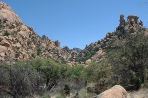
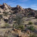
Texas Canyon Back Country Rock Formation

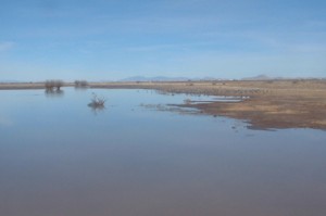
As you drive on Interstate 10 through the Little Dragoon Mountains about 15 miles east of Benson you will find an area that is in stark contrast to the San Pedro River Valley. Texas Canyon is a massive granite formation that has weathered over the eons to create a jumble of rocks that catch the eye. The granite formation can be seen as you drive past on the interstate or when you stop at the rest areas. The rest area gives you some nice views of the rock pillars and boulders but you are fenced in and you can’t really get out to explore the area. If you take exit 318 you will be able to find some spots to wander around and see a little of what is here.

When Barb and I were first coming to southeastern Arizona looking for a location to build Down By The River B and B, we drove through Texas Canyon. We would often think how fantastic the rock structures were in this area. We wished that we could have moved some of this area to Saint David and placed it along the San Pedro River right next to the BnB but alas it was 25 miles away.  The rocks are scattered over a large area and it almost looks like some giant was playing with them and then just left after he was done.

Texas Canyon Picture

Texas Canyon scattered trees offers some shade while you enjoy the views

During the eight years the b and b has been opened, we have traveled past or through Texas Canyon on our way to somewhere else. Usually we have taken the turn off to go to the Amerind Foundation Museum, The Triangle T Ranch for dinner in the saloon, or just to take a shortcut to Arizona 191 on our way to various places in the Sulphur Springs Valley. We never took the time to stop and see what the back country was like.

Recently, Angie and I decided to take a short day trip from Down By The River B and B to Sunsites and head  to the trail head for a hike up to Cochise’s Stronghold in the Dragoon Mountains. Naturally I was going through Texas Canyon as we exited the freeway on Dragoon Mountain Rd. But instead of making the turn and driving on to our destination, I decided to take some time to see what I had been missing. I turned left under the freeway and took 4Y Ranch Road into the back country north of the freeway. The one lane road doesn’t go far, maybe a mile, and you finally reach  the cattle guard and the ranch gate.

Texas Canyon Valley Picture

Texas canyon has some valleys that drop that will beg you to explore them

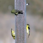
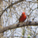
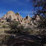
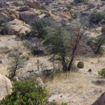
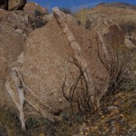
We backtracked a little and found a place to get off the road. With a nice morning sun, we decided to walk around and see what the area had to offer. It turned out that long with the enticing rock formations, the area has yucca, ocotillo, cactus of various sorts and scattered trees that dot the terrain. We also saw signs of coyote, deer and the occasional bird that fled our advance. On previous travels though the area I have various seen birds fly across the road and I have spotted hawks that are watching for prey. But since this is winter, I didn’t expect to see a lot of activity.

As we walked around the area we notice the rocks were crossed by thinner lines of a different type of lighter colored material. At first I thought that since this area was a shallow sea way back in prehistoric times that these strata I was seeing in the rock were probably layered like sandstone and then hardened. My originalthesis turned out to be wrong. After investigating, we later learned that this entire area was formed about 50 million years ago when magma pooled below the surface of the earth and

Boulder Picture

There are rounded rocks in Texas Canyon that are layered with strata.

slowly cooled forming the rocks geologists call quarts monzonite. The strips of fine grain material is actually called Aplite and it is formed during the granite formation process. Unlike the Chiricahua Mountains the area never became an explosive volcano since the magma never reached the surface of the earth. Over the years the earths surface eroded away and left the rocks. Weathering from wind and the freeze thaw cycle started breaking the rocks down and rounding the corners giving the rocks spheroid shapes. As the softer rock was worn away the denser rock would sometime be sitting on the small support underneath and you get the proverbial “Balanced Rock”.

After the geology lesson, come on forward to the more modern times and I will tell you more about who inhabited Texas Canyon. The area has been found to to contain petroglyphs and pictographs on the boulders and was the area was sacred to the Native American inhabitants. I can see why that was because it is awe inspiring when you are amongst the boulders. Cochise is said to have used this area for his winter camps. In 1858, the Butterfield Stage Route ran through Texas Canyon on its way to Benson after leaving Apache Springs near Fort Bowie in the Chiricahua Mountains. The stagecoach line was awarded the mail contract from the US Government and carried mail and passengers from Saint Louis, MO to San Francisco. The stageline lasted until the start of the Civil War when the troops were withdrawn to fight in the war. With no military protection from the Apaches, the stage route was abandon. The area was controlled by Cochise and his Chiricahua Apaches until he made peace with the US in the 1870s. In the late 1880s David Adams settled in the area. He was from Coleman County Texas and he was followed by his brother William in 1895. Over the years

Texas Canyon Cemetary Panel Picture

Texas Canyon Pioneer Cemetery information panel. Click the picture to enlarge

other family members followed the brothers and settled in the area. It became known as Texas Canyon because of all the Texans that lived up there. The Adams family cemetery is located on the Amerind Foundation grounds along the road that leads into the museum parking lot.

There are a couple of places in Texas Canyon that need to be mentioned. In 1927, the Triangle T Ranch got its name from the new owner Metta Tutt. The ranch became a dude ranch and later was used to house the Japanese Diplomats during World War II.  Parts of the ranch have been used as movie sets including the original 3:10 to Yuma with Glenn Ford and Tombstone. The television production Young Guns also used the property as a set. Other pictures have been made in the area and notable people have visited the place. Just a little further south is the location of the Amerind Foundation. In the 1930s William Shirley Fulton established The Amerind Foundation in the canyon where he was doing archeological digs. The Museum features much of what was found in the area along with artifacts from Mexico and South American cultures. The Foundation is celebrating it’s 75th Anniversary.

This gives you some of the highlights of the area and it is a short 30 minute trip from the Down By The River, The Lodging Hub of Cochise County. I will be doing some more blogging on the Amerind Museum and what you can see when you visit. We have seen birds in the area but probably one of the strangest things I have seen at the Amerind was the vultures that were flying up into the tall trees to roost toward the end of the day. Naturally I didn’t have my camera with me for that shot. I still need to jog my memory to bring a camera when I am going places. It never happens to fail – there is always a great shot when I don’t have the camera. You think I would learn.

Birding Areas Near Down By The River B and B

January 20th, 2013 by Mike Hug

Gold finch at feeder

Lesser Goldfinch and Warblers love to visit the feeders

Birding is one of the many things to do in Southeastern Arizona, in particular Cochise County, and our B&B is near to all these locations. In fact there is a path to the San Pedro River that is right out the back door of our BnB. The B and B is located on the west side of the tree lined San Pedro River away from the noise of Highway 80. We keep most of the 15 plus acres of the property natural so that the wildlife has shelter and food sources. We do keep feeders for the birds and the resident birds frequent them. Many finches, sparrows, doves and quail frequent the feeders during the day. During the spring summer and fall the hummingbirds are always around to grab a sip of nectar. There are the territorial hummingbirds that run the others off but once in a while a hummingbird will hold it ground and fight. If you want to get up close and personal, sit in a chair on the patio, sip some wine and  wear some read ear rings. You may hear a hum next to your ear. turn slowly as it will probably be a hummingbird looking for a drink.

We do get the Raptors at times that come over the field on the hunt. I did do a blog on a Northern Harrier that

Northern Harrier Picture

Northern Harrier flies low over the back acreage looking for prey.

spent most of the spring gliding over the property. He was back again in the fall and we see him every once in a while this winter. In the mornings and afternoons during the spring we have some American Kestrels that show up and hover over the fields. It is fun to watch them dive down for a morsel and fly back up to a limb and then repeat the cycle. We do have Red Tail Hawks in the area but last summer we had something larger. It took a while but I got a long shot at the bird sitting on a limb of a tree at the river. After walking toward the tree I saw how big the limb was and my best guess along with some other birders that were here was that we had spotted a golden eagle. We saw that bird many times over the summer. Just after the New Year we were coming home late at night and an owl took flight from a pole as we came around the corner. We couldn’t tell what type but there have been Great Horned Owls seen at the San Pedro by Angie and me last summer. Check out this list we have of birds that have been spotted on the property.

Vermillion flycatcher picture

Vermillion Flycatchers are found in the San Pedro River area and on the property of Down By The River B and B in St.. David.

There are other locale areas that are near the bnb in Benson and St. David. Benson has a birding trail that is near the waste water plant along the San Pedro River. This can be reached by heading north on Ocotillo Road at the corner where Safeway is located. Go under the I – 10 freeway and turn right at the sign for the San Pedro Valley Golf Course. Turn left at the T and follow the road to the waste water plant. The other local area is the Holy Trinity Monastery that is about 1/2 mile north of the B and B on the east side of the river. The Monastery has an award winning birding trail that was dedicated in 1993 that starts on their property. The Monastery also has pond and 150 acres of open area adjacent to the tree lined river. There is also a trail south of St. David along the San Pedro River at Fairbanks. This trail is wooded and goes back to the ghost town of Contention. For other birding areas click here for a list of locations and then reference the map below to get a perspective of distance from the B & B.

It has been a bit on the cold side in Arizona over the last week and so the birds are really hitting the feeders. It

Black-chin picture

Black-chinned Hummingbird taken by our guest Egil from Norway.

seems that the year is moving along relatively fast for us. Christmas came and went and now we are half way through January. The birds will start migrating back through the area in March and April. In April of 2008, we had a birder that spent three days at the b and b either on the porch or with occasional walks to the river and sited 53 birds. She was very excited that she could find such a large population in such a small area. I was amazed that she could identify that many birds in such a short time. Migration isn’t too far off and we have future guests that have already made their reservations for that time of the year. Check out our list of the birds that have been seen on the property and at the San Pedro River that flows behind the property.  Come join us and see what we have to offer. We are centrally located so that trips to other birding areas are close by.  We just updated the map. Please right click on the map below and click on view image to get the full size map and you can see what I mean.

Cochise County Map

Down By The River B and B is “The Lodging Hub of Cochise County” and you can see all the things to do in the area from this map

Bird Watching In Cochise County

January 15th, 2013 by Mike Hug

San Pedro River

The San Pedro as it leaves the northern boundary of the San Pedro National Riparian Conservation Area

Some of the best birding in the United States is found in Cochise County. There are locations in the County from the sky islands to the San Pedro River that have great birding at different times through out the year. Approximately 400 species of birds can be found with approximately 250 that use the San Pedro River on their migration in the spring and fall. The San Pedro River is the last free flowing river in Arizona. It flows all year around and originates in Mexico, flows north through St. David and Benson to end at the Gila River in the near Superior and Globe. Depending upon the time of the year the river may not be surface water north of Saint David but will become an underground river. The San Pedro National Riparian Conservation Area encompasses the San Pedro River from the Mexican border to the south end of Saint David. At the northern end of the San Pedro National Riparian Conservation Area is the location of Down By The River B and B a centrally located San Pedro River BnB with access to the San Pedro River and the great birding that can be found there.

Birds also use various locations in the county to stay the winter. A good example is the Sulphur Springs Valley, where the Sand Hill Cranes winter at White Water Draw and at the Willcox Playa. Other water birds are at these locations during the winter. These two areas have large areas of water during the winter but in the summer the lakes are small if there at all. During the winter at White Water Draw you will find raptors including owls that inhabit an old barn  that is on the site. As spring weather comes so do the flycatchers.

White Water Draw Picture

Thousands of San Hill Cranes, along with other birds, winter in White Water Draw.

The sky islands of the Huachuca, Dragoon, Mule and Chiricahua Mountains all have different birding areas. The foothills going to these locations will also have birding opportunities. During the winter, some of these areas may be closed or restricted due to snow. The sky islands have peaks from 8,000 to over 10,000 feet in elevation. In certain areas access can be with by a normal car but some of the back country treks need a high clearance vehicle.

Birding can be done throughout the year in this area with different venue that become available during the different seasons. So if you are an avid birder or are just starting out learning about birding,

Dragoon Mountains

The Dragoon Mountains offer many opportunities for birding and hiking.

Cochise County offers a lot for all types of birding enthusiasts. Down By The River B & B is also known as the Lodging Hub of Cochise County and offers you a great place to stay while enjoying your time bird watching. Try us out and see what we have to offer. You won’t be disappointed.

Read Old Tombstone Newspaper Stories

January 4th, 2013 by Mike Hug

Back in April 2012 I wrote a piece concerning Tombstone near, our B&B, about the Tombstone Archives. The Archives have a lot of items and papers in their possession about the town of Tombstone. However they don’t have the day to day happenings of the town. A little more research is needed for that.

OK Corral article

Partial article written in 1881 about the shootout at the OK Corral

Recently our friend Bob, who works at the Benson Visitors Center, showed me a website that opens up a whole new way to find out information. The website is from the Library of Congress and it has many newspapers from all over the United States with copies that range from 1836 to 1922. Not all the newspapers nor all the issues of a newspaper are there but you can search for names, events or just what was reported on a certain date in a certain town or state. They may not show up in the specific paper that you think would have the information but may be in others.

Now just about everyone who has knowledge of the Old West knows that there was a shoot out at the OK Corral. Tombstone, the gunfight and Wyatt Earp have been glorified in many movies, TV shows and books over the years. But have you ever seen a written account from that time period that gives you the newspaper report? I hadn’t seen one until I did the search of the Library of Congress website. On the website I found a long article about what happened and what led up to the fight. The article is a copy of the one written up in the Tombstone Nugget which was a daily paper that was printed in Tombstone during that time period. The article was reprinted in a Tucson paper, The Arizona Weekly Citizen, on October 30 1881 4 days after the shoot out happened. I have copied a portion of the article here but if you would like go read the article in the Citizen then  click on the link. The article is at the start of the seventh column.

Now if you want to visit Tombstone you should consider where you are going to stay. There are many things to see in Tombstone including the Graveyard at Boot Hill where the McLaurys and Clanton are buried. Spend the day and watch the gunfight reenactment at 2 PM daily. Down By The River B and B is less than a half hour drive to Tombstone. The San Pedro River BnB is centrally located to many different historical locations, birding sites, wineries and also State Parks and National Monuments. For a peaceful and relaxing stay visit our website and see what great destination Down By The River B&B is for your lodging experience.

  • Archives

  • Categories

»