
Southeast Arizona Things to Do near Down by the River Bed and Breakfast
Southeast Arizona Things to Do near Down By The River Bed and Breakfast
Southeast Arizona Things To Do? This is always a question we are asked and the answer is simple. Southeast Arizona has many things to do including sightseeing, touring ghost towns and historical sites, hiking, bird watching and many other different activities. The Southeast Arizona things to do list is large and varied to allow for different types of fun and Cochise County is a great place to do discover that. Depending on what you like to do there is a plethora of items you can put onto your agenda. But remember Cochise County is large, even bigger than some states and the time to see things always takes longer because you come across interesting things that turn minutes into hours. That is why you need a centrally located Lodging Location such as Down By The River B and B, the Lodging Hub of Cochise County.
Since our San Pedro River B and B is centrally located and near the major highways that cross this part of southeast Arizona, we wanted to share just what is available to you when lodging at our San Pedro River B and B. Depending upon your interests here are some places you might like to see while you visit. There are more things to do in the area that are not mentioned here but this will give you a great start. The locations are in alphabetical order so check out the locations from this map that that we have of the area. All references to travel times and locations are taken from the b and b.
Southeast Arizona Things To Do – Parks, Museums, Historic Sites and General Activities
Amerind Foundation Museum
Take I-10 east to exit 318 and head south for about 1 mile then turn left. The museum has Indian and Spanish artifacts as well as an art museum and is open Tuesday to Sunday from 10 AM to 4 PM.
Bisbee
The town is located about 45 minutes to 1 hour south on AZ 80. The Mining Museum looks at the different mining activities that took place in Bisbee. You can also take the Copper Queen Mine tour and look down into the Lavender Pit Mine at a roadside stop. The mine tour into the Copper Queen mine is an actual ride into the mine but wear warm clothes as it is near 50 degrees inside. The town is very photogenic and there are a lot of architectural features to see. The town is built in a canyon with the houses built on the sides of the canyon. The downtown has old buildings that are still used for businesses today. There are many shops to visit in this town. Also see Warren.
Cascabel
To follow the road to Cascabel, take I-10 east to Pomerene Road, exit 306, and then travel about 1 hour north. This is a dirt road most of the way and ends up in San Manuel. Along the way there is a crested Saguaro visible on top of a hill along the road. Cascabel also has The Oasis Sanctuary which is home to some exotic birds.
Chiricahua National Monument
This is about 1 hr 30 minutes to the park entrance. To get there take I-10 to the east get off at the first Willcox exit. As you reach the center of town you will see a sign for the monument. Turn right and head south on AZ 186. The park tops out at 8000 ft and there are a lot of rock formations that have eroded from the elements after a volcanic blast millions of years ago. This has a lot of white hoodoos and the effect is similar to Bryce Canyon National Park only a smaller scale.
As you travel on the road from Willcox to the Chiricahuas there are some old homes that are in Dos Cabezas, a photogenic area. They are just off the road but there is no place to stop at that location. You don’t see them until you hit the rise and then you’re past them. After leaving the Chiricahuas you can return the way you came or take the more scenic route by going south on 181. You will drive along the Chiricahua Mountains until you finally turn west to 191 and Sunsites. 191 goes back to I-10 along the Willcox Playa.
Coronado National Memorial
The Monument is about 1 hour away and is located south of Sierra Vista on highway 92. This is near the location where Coronado entered this part of the US on his search for the Cities of Cibola.
Council Rocks
This is about a 1 ½ hour trip on a rough road. Council Rocks is located on the west side of the Dragoon Mountains and is purported to be a location that Cochise met with General Crook to talk about a peace treaty. The area has a natural amphitheater that was used by the Apache for council meetings. Also in the area are pictographs that are over 1000 years old. We can give exact instructions to our guests on how to get to Council Rocks.
Douglas
Douglas, Arizona is located 1 1/2 hours south on AZ 80. The only thing in this town that is the thing to see is the Gadsden Hotel. The lobby has a marble staircase that goes up with stained glass panels depicting a desert scene that covers 30 to 40 feet in length and close to 8 feet tall. The hotel restaurant is also worthy of a visit.
Fairbank
Fairbank, Arizona is located along the San Pedro River and is an old ghost town. It is located about 20 minutes away. Drive south on 80 and then turn west on 82 just before Tombstone. The parking lot is just before the San Pedro River and is an old mining processing center. Some buildings have been restored and some are in ruins. The visitor’s center is usually open on Saturdays. Also see Presidio Santa Cruz de Terrenate.
Fort Bowie
This site is little over an hour from here to the east on I-10. Get off on the Bowie exit, drive through town and turn right onto Apache Pass Rd taking it about 14 miles onto a short dirt road and parking lot. There is about a mile and a half easy hike to Fort Bowie. This could be a morning thing and the Chiricahua National Monument in the afternoon. The ruins of the old cavalry fort, used in the Apache wars, are at the end of the trail. It is interesting because of the history of this area and the visitor’s center gives you a lot of information. Also the trail goes by the ruins of Apache Springs Way Station and crosses the Butterfield Stage Route used to carry mail and passengers in the 1850s. There is a graveyard where Geronimo’s son is buried and the Tom Jefford’s Indian Agency ruins are here. This is also the location of the Bascomb Affair which is the cause of the Apache wars.
Fort Huachuca
This site is a little over an hour from here to the southwest and Sierra Vista. The museum is accessed by going to the main gate of the Fort. Fort Huachuca was the home of the Buffalo Soldiers that were active during the Apache Indian Wars. Only American citizens are allowed on post.
Gammons Gulch
Located about 1 hour north on Pomerene Road is Gammons Gulch. This is a small production movie studio set that does tours. There are a lot of different things to see on the tour and Jay Gammons, owner/tour guide, is a fascinating person to listen to and has many tales to tell. He has been in pictures as was his Dad. But I will let him tell you those stories.
Gleeson Ghost Town
Located to the southeast of Tombstone about 18 miles. Take Gleeson Road (Left from Hwy 80) south of Tombstone. The town was first established as Turquoise in the 1890s, and the mine was shut down in 1958. There are standing ruins for you to see. Read about it my blog.
John Slaughter Ranch Museum
This is about 1 ½ hours south on 80. After you reach Douglas, go east on 15th St to reach the John Slaughter Ranch. Texas John Slaughter was one of the first people to drive cattle out of Texas to the rail heads in Kansas. He was also the Sheriff of Cochise County and was instrumental in bringing law and order to Cochise County after the Indian Wars were over. The museum is part of the Old San Bernardino Spanish Land Grant.
Kartchner Caverns
Kartchner Caverns can be seen from the B and B but is about 35 minutes from us. Take 80 back into Benson get on I-10 west to 90, about a mile, and then take 90 south. The Caverns take reservations and there are 2 different tours. One of the tours, The Big Room, is only open from October 15 to April 15. Tours take about 1 ¼ hour and there is a 15 minute informative movie that you can see before the tour. You can’t take cameras or purses on the tour so leave them in your trunk before you arrive. The cave is 98% humid and at about 68 degrees. You will not need a jacket. If you make reservations for a day after you arrive here, set them up after 11AM so that you aren’t rushed at breakfast.
Old Pearce
Old Pearce is located south on 191 about an hour south of I-10. This is a ghost town, but most buildings are still standing. A fair is held there every year during Thanksgiving weekend.
Presidio Santa Cruz de Terrenate.
On the opposite side of the river from Fairbank is an 18th Century ruins of a Spanish Presidio. To get there take 80 south and turn west on 82 past Fairbank. Cross the San Pedro River and take Unbalanced Ranch Road to a parking lot. The trail-head to the ruins of an old Spanish Presidio heads toward the river and is a relatively easy 1+ mile walk.
Rex Allen Museum
The Rex Allen Museum is located on Railroad Avenue in downtown Willcox. The museum celebrates the life of the movie star, the original Singing Cowboy. The Marty Robbins Museum is also a couple of buildings away.
San Pedro Valley Observatory
With the dark skies in Cochise County we are lucky to have the world famous astronomical San Pedro Valley Observatory. The Observatory is located just east of Benson off Old Benson Airport Road. You can reserve time with an astronomer who will show you many different things from planets to deep space objects such as galaxies, nebula, and open and globular clusters.
Texas Canyon
Take I-10 east to Exit 318, about 30 minutes east into the Dragoon Mountains. This has interesting rock formations to view. There is horseback riding rental facility and good BBQ located at the Triangle T Ranch. The ranch started as a dude ranch and was also the location for the internment of Japanese Diplomats during WW2.
The Thing
The Thing is a museum located at exit 322 on Interstate 10. It only costs $1 and if you like Dairy Queen ice cream it can be a fun stop. For more information see our blog.
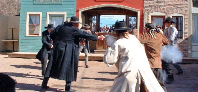
Tombstone
Legendary Tombstone, Arizona is located about 20 minutes south on AZ-80. The town is a historical site with many old buildings including the courthouse museum. Boothill is on the left as you come into town. The graveyard now has newer grave markers that contain the old historic wording. The Clanton’s and McLaury’s, from the gunfight, are buried here. If you don’t do anything else, see the Bird Cage Theater. There is also the Epitaph Newspaper Museum and the Rose Tree Museum with a rosebush that is over 120 years old, covers over 8000 square feet and blooms in April. There is also a mine tour that takes you down into an old silver mine. As always there are gunfights but at 2 PM every day there is a reenactment of the gunfight at the OK Corral. Helldorado Days is the big event held in October. There is a lot more to see and do in this town. Our Tombstone B and B is just minutes away from all the action.
Warren
Warren, Arizona is part of Bisbee. This was the mine executives housing area. There are many interesting old houses and mansions along the park somewhat like the National Mall in Washington DC.